Seismic measurements are used for visualization of geological, archaeological and another object buried under the surface. The only necessary condition is a difference in elastic (e.g. velocity of seismic waves or their attenuation) properties between the target structures and the geological surroundings. The most common applications are within the field of geological mapping and prospection of mineral resources for assessment of lithological boundaries, fault zones, or finding a thickness of sedimentary basins. In construction industry it could be used to characterize building sites, map tectonically stricken and heavily weathered areas or for seismic hazard estimation (the VS30 parameter). The archaeological applications often deal with finding of buried walls and ditches.

Determination of S-wave velocity propagation to the depth of 30 m (parameter VS30) using surface wave analysis. The first step is to determine the dispersion of surface waves (changing the velocity of wave propagation depending on the frequency).
Afterwards it is possible to calculate the velocities of wave propagation at different depths.


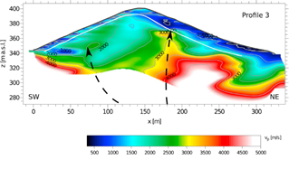
Visualization of the internal structure of the volcanic cone Zebín (near town Jičín).
Magma inlet paths (shown by the dashed line) are mapped by significant increases in seismic wave propagation velocities.
