The Department of Applied Rock Mechanics studies rocks and their short- and long-term changes depending on endogenous and exogenous factors. This includes monitoring and analysis of rock masses depending on rock composition and its properties, precipitation or temperature. In addition to direct monitoring in natural conditions, it uses a fully equipped rock mechanics laboratory, which allows the investigation of rocks' basic and advanced physical and mechanical properties.
Infrared thermography reveals weathering hotspots at the Požáry field laboratory. Online
2024
Publication: Loche M, Racek O, Petružálek M, Scaringi G, Blahůt J (2024) Infrared thermography reveals weathering hotspots at the Požáry field laboratory. Online. Scientific Reports, 14(1). https://doi.org/10.1038/s41598-024-65527-x
Assessing the influence of temperature on slope stability in a temperate climate: A nationwide spatial probability analysis in Italy
2025
Publication: Loche M and Scaringi G (2025) Assessing the influence of temperature on slope stability in a temperate climate: A nationwide spatial probability analysis in Italy. Online. Environmental Modelling & Software, 183. https://doi.org/10.1016/j.envsoft.2024.106217
Image
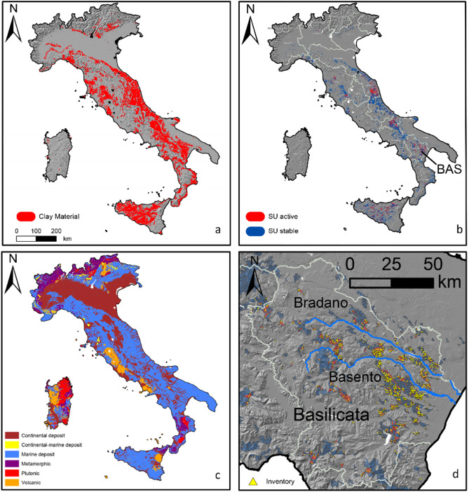
Fig. SUs containing clay materials in Italy (a) and distinction between active and stable SUs, where flat areas have been cropped out (b). Geological materials: Volcanic, Plutonic, Metamorphic, Marine Deposit, Continental-Marine Deposit, Continental Deposit according to the geological map with national coverage 1:500 000 (Compagnoni et al., 1976–1983) managed by ISPRA (c). Distinction between active and stable SUs in Basilicata (BAS), a region in southern Italy. Total count of landslides: 16 530; binarized SUs: 5572 (d).
Source area morphometry and high depletion rate of landslides may indicate their coseismic origin
2024
Ancient coseismic landslides indicate prehistoric earthquakes and may also be a measure of their intensity. Their identification in the landscape remains, however, challenging. We used field geologic observations of source areas of recent rainfall-induced and earthquake-induced landslides to define a morphometric index that can distinguish between these two types of triggers. ..
Publication: Baroň, I., Jelének, J., Klimeš, J., Dong, J-J., Melichar, R., Šutjak, M., Chen, Y., Yang, C-M., Zhang, E-L., Méndez, J., Tseng, C-H., Hartvich, F., Blahůt, J., Nguyễn, T-T., Kociánová, L., Bárta, F., Dušek, V., Kycl,P. (2024) Source area morphometry and high depletion rate of landslides may indicate their coseismic origin. Engineering Geology. 330: 107424. https://doi.org/10.1016/j.enggeo.2024.107424.
Image
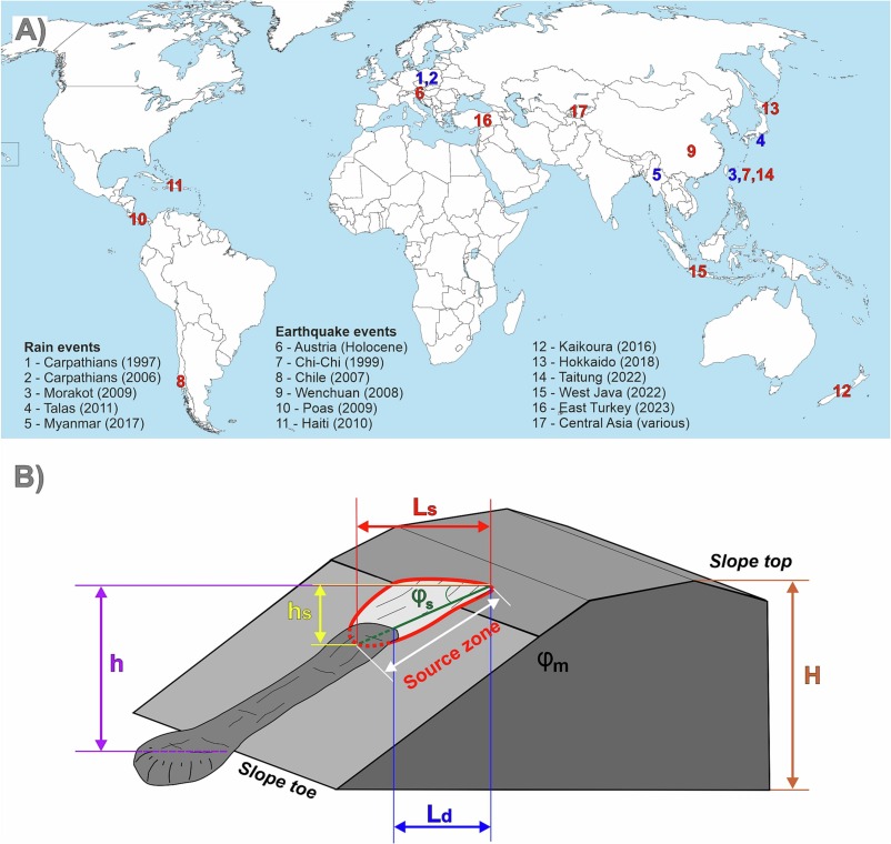
Fig.: General inputs of the study: (A) Overview of the analyzed lerainfall and earthquake landslide events, (B) Schematic model showing the input parameters and morphometric characteristics of landslides´ source zones for calculating the Index of Potential Trigger (IPT). The depletion index Id (Eq. 1) is calculated based on the length of the depleted part (Ld) and the length of the whole source area (Ls), while the source area angle (φS) that is assumed to be much lower at the coseismic slope failures than the host material friction angle (φm) can be calculated from the source area height (hs) and Ls. Relative slope height (Hrel, Eq. 2) is the ratio between landslide scarp top height above the slope toe (h) and the entire slope height, i.e., the elevation difference between the ridge/slope top, and the valley floor (H).
A benchmark dataset and workflow for landslide susceptibility zonation
2024
Landslide susceptibility shows the spatial likelihood of landslide occurrence in a specific geographical area and is a relevant tool for mitigating the impact of landslides worldwide. As such, it is the subject of countless scientific studies. Many methods exist for generating a susceptibility map, mostly falling under the definition of statistical or machine learning. These models try to solve a classification problem: given a collection of spatial variables, and their combination associated with landslide presence or absence, a model should be trained, tested to reproduce the target outcome, and eventually applied to unseen data..
Publication: Alvioli M, Loche M, Jacobs L, Grohmann CH, Abraham MT et al. (2024): A benchmark dataset and workflow for landslide susceptibility zonation. Earth-Science Reviews, Volume 258. https://doi.org/10.1016/j.earscirev.2024.104
Image
Fig.. Geographical location (inset) of the area covered by the slope unit set (main figure) selected in this work as a benchmark dataset for landslide susceptibility zonation. The dataset is a subset of the slope unit map obtained by Alvioli et al. (2020), and used by Loche et al. (2022) for a landslide susceptibility map of Italy. In the dataset proposed here, we selected point locations of translational landslides from the Italian national inventory known as ‘IFFI’ (Trigila et al., 2010). Map is in EPSG:32632 projected reference system.
The effect of tree growth disturbances inertia on dendrogeomorphic spatio-temporal analysis of landslides: A case study
2023
Publication: Šilhán K., Fabiánová A., Klimeš J., Tábořík P., Hartvich F., Blahůt J. (2023): The effect of tree growth disturbances inertia on dendrogeomorphic spatio-temporal analysis of landslides: A case study. Catena 235, 107678. doi.org/10.1016/j.catena.2023.107678
Discrimination of doubled Acoustic Emission events using Neural Networks
2024
Publication: Petr Kolář, Matěj Petružálek (2024): Discrimination of doubled acoustic emission events using neural networks. Ultrasonics. Vol. 144, Dec. (2024), no. 107439. ISSN 0041-624X. E-ISSN 1874-9968, DOI: https://doi.org/10.1016/j.ultras.2024.107439
New Insights into the Internal Structures and Geotechnical Rock Properties of the Giant San Andrés Landslide, El Hierro Island, Spain
2023
The San Andrés landslide on El Hierro (Canary Islands) represents a rare opportunity to study an incipient volcanic island flank collapse with an extensive onshore part. The presented research improves the knowledge of the internal structure and rock characteristics of a mega-landslide before its complete failure. The onshore geophysical investigations helped detect the possible San Andrés landslide sliding surfaces at depths between 320 m and 420 m, with a rather planar geometry and they also revealed that rocks inside and outside of the landslide had similar properties which suggests that the previous fast movements of the landslide did not affect the bulk properties of the displaced rocks. Publication: Klimeš, J.; Hussain, Y.; Mreyen, A.-S.; Cauchie, L.; Schlögel, R.; Piroton, V.; Petružálek, M.; Blahůt, J.; René, M.; Meletlidis, S.; Havenith, H.-B. (2023) New Insights into the Internal Structures and Geotechnical Rock Properties of the Giant San Andrés Landslide, El Hierro Island, Spain. Remote Sens., 15, 1627. https://doi.org/10.3390/rs15061627
Image
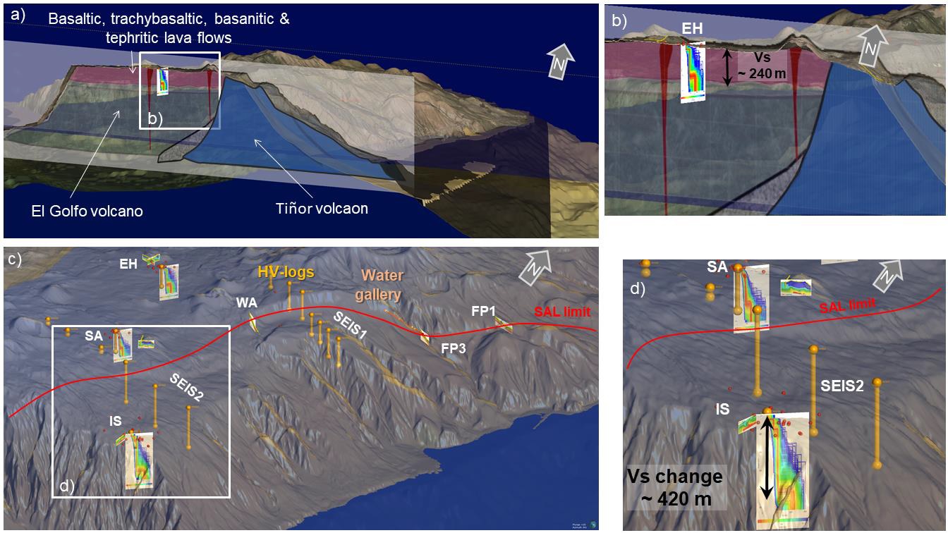
Fig. 3D geomodel of the studied El Hierro. (a) The central part of the SAL with inserted geological cross-section and geophysical results with the detailed view in the inset (b); (c) view of the SW part of the San Andrés landslide with the results of the geophysical measurements and detailed view in the inset (d).
Rate-dependency of residual shear strength of soils: implications for landslide evolution
2023
Publication: Duque, J., Loche, M., & Scaringi, G. (2023). Rate-dependency of residual shear strength of soils: implications for landslide evolution. Géotechnique Letters, 13(2),1-8. https://doi.org/10.1680/jgele.23.00004
Rock Surface Strain In Situ Monitoring Affected by Temperature Changes at the Požáry Field Lab (Czechia)
2023
Publication: Racek O., Balek J., Loche M., Vích D., Blahůt J. (2023) Rock Surface Strain In Situ Monitoring Affected by Temperature Changes at the Požáry Field Lab (Czechia). Sensors 23(4), 2237. https://doi.org/10.3390/s23042237
Observation of the rock slope thermal regime, coupled with crackmeter stability monitoring: initial results from three different sites in Czechia (central Europe)
2021
Článek popisuje univerzální, modulární a finančně dostupný systém monitoringu skalního svahu. Pomocí tohoto systému, je možné in-situ pozorovat klimatické proměnné, teplotu v povrchové vrstvě skalního svahu až do hloubky 3 m a dynamiku vybraných diskontinuit v čase. První výsledky ukazují na rozdíly pozorované mezi jednotlivými lokalitami. Pro budoucí rozsáhlejší statistickou analýzu dat, budou použity delší časové řady. Dále budou data využita pro analýzu dlouhodobých trendů a numerické termomechanické modelování.
Racek, O., Blahůt, J., and Hartvich, F. (2021): Observation of the rock slope thermal regime, coupled with crackmeter stability monitoring: initial results from three different sites in Czechia (central Europe), Geosci. Instrum. Method. Data Syst., 10, 203–218, DOI: 10.5194/gi-10-203-2021
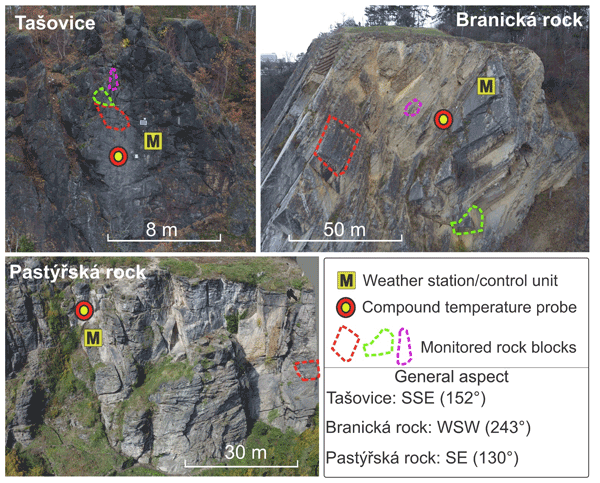
Snímek zachycuje tři osazené lokality skalního svahu. Jednotlivé monitorované bloky jsou označené přerušovanou čarou s rozdílnou barvou. Dále je vyznačena poloha meteostanice a teplotního čidla ve vrtu.
Experimental laboratory of rock properties in the former Požáry quarry (Prosečnice)
Experimental measurements of changes in rock properties in natural conditions are conducted in a field laboratory located in the former granodiorite quarry Požáry near Prosečnice in Central Bohemia. The monitored variables, and instruments, include:
Climatic monitoring (precipitation, temperature, humidity and air pressure, wind direction and speed)
Incoming and reflected radiation (pyranometers)
Crack movement (induction and VW crack meters)
Surface tension (film strain gauges)
Rock mass moisture (apparent dielectric permittivity/capacity method)
Rock mass temperature measured (thermocouples up to 3 m depth)
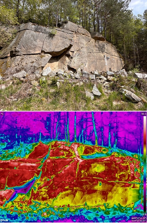
Surface thermal properties (IR cameras)
Apparent resistivities within the rock mass (electrical resistivity tomography - ERT)
Our ongoing research focuses on examining the impact of temperature on alterations in rock mass properties, specifically changes in stress and strain, influence of thermal shock and temperature distribution on the surface and within the rock mass. Additionally, we study the rate and distribution of moisture on both the surface and within the rock mass.
Team: Mgr. Jan Blahůt, Ph.D. Mgr. Ondřej Racek MSc. Marco Loche, Ph.D.
Racek O, Balek J, Loche M, Vích D, Blahůt J (2023) Rock Surface Strain In Situ Monitoring Affected by Temperature Changes at the Požáry Field Lab (Czechia). Sensors 23(4): 2237. https://doi.org/10.3390/s23042237
Racek O, Blahůt J, Hartvich F (2021) Observation of the rock slope thermal regime, coupled with crackmeter stability monitoring: initial results from three different sites in Czechia (Central Europe). Geoscientific Instrumentation, Methods and Data Systems, 10: 203-218. https://doi.org/10.5194/gi-10-203-2021
Loche M, Scaringi G, Blahůt J, Melis MT, Funedda A, Da Pelo S, Erbì I, Deiana G, Meloni MA, Cocco F (2021) An infrared thermography approach to evaluate the strength of a rock cliff. Remote Sensing 13(7): 1265. https://doi.org/10.3390/rs13071265
Laboratory of Rock Mechanics
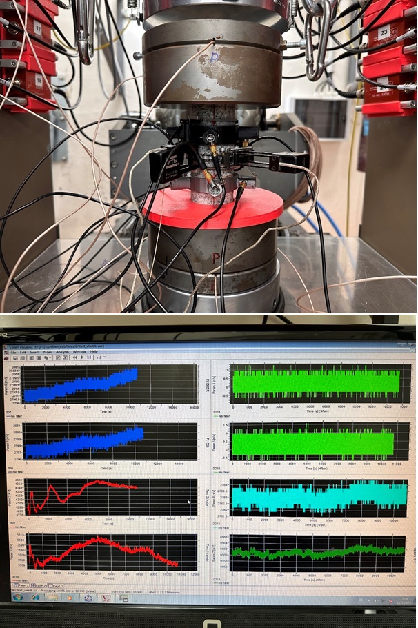
The laboratory deals with determining the physical and mechanical properties of rocks. This includes assessing bulk and specific density, porosity, permeability, and strength through various tests such as unconfined compression test (UCS), tensile strength test (Brazilian test), fracture toughness test, triaxial test, and shear strength test. Additionally, we determine the static and dynamic moduli of rocks and measure the anisotropy of rocks under different pressures. These evaluations are conducted using the instruments listed in the "services" section.
Team: Dr. Xuan-Xinh Nguyen, Ph.D. Ing. Tomáš Lokajíček, CSc. BSc. Artëm Polezhaev MSc. Ghazaal Rastjoo
Booking can be made by contacting the responsible person at the laboratory.